


açıklaması Field Topography UTM free
Topographical calculations for UTM & WGS84. Grid on the map.
Calculations in full or brief coordinates, in one or in the adjacent zones.
Rectangular coordinates in meters. Altitude, range in meters.
All angles on scale 64-00 or 60-00 (settings option on main screen).
In DGP and IGP angles are available in degrees - minutes – seconds.
GPS location in rectangular coordinates.
Azimuth of the Sun, the Polaris in specified time.
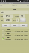
Maintain a list of objects that may be used in which the tasks (250). In free ver. - 3.
Read / write and append data from a file. The data file may edit/prepare a text editor, transfer methods available.
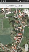
Google Maps, ArcGIS, MapBox, prepared ofline-atlases with markers points from the list (only with full coordinates).
Atlases in the format *.mbtiles can be created in SAS Planet, MobAC. Based on osmdroid.
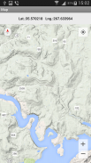
UTM-Grid on the map.
When you touch the marker shows the number and name of the point.
When you touch the map shown rectangular coordinates of the location.
Maps are cached (accumulated) to work without a network.
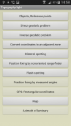
Tasks list:
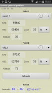
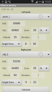
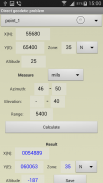
Direct geodetic problem;
Inverse geodetic problem;
Convert coordinates to an adjacent zone;
Localizing with paired observation (readout from the base or directions);;
Binding undirected rangefinder (range up to 2 known points);
Binding by measured angles(between the left-middle and middle-right known points with anchor points);
Binding according to GPS (geodetic and rectangular);
Azimuth of luminary;
Localizing with a stopwatch (with the air temperature);
Map.
Settings:
- Maps ( Google / ArcGIS / MapBox / prepared offline-atlases);
- The scale of thousandths (60-00 , 64-00)
- Color style
- The type of map (topographic, satellite, hybrid)
- Type of marker points on the map
- Grid on the map (no , 1km , 2 km )
- Save data to a file, read / write and append data from a file.
The program is distributed "as is". Its use - discretion and responsibility of the user.
All tasks and all the features available in the full version.
UTM ve WGS84 için topografik hesaplamalar. Harita üzerinde ızgara.
Tam veya kısa koordinatlarda, bir veya bitişik bölgelerde hesaplamalar.
Metre cinsinden dikdörtgen koordinatlar. Rakım, metre cinsinden aralık.
Ölçekte tüm açılar 64-00 veya 60-00 (ana ekranda ayarlar seçeneği).
DGP ve IGP açılarında derece - dakika - saniye olarak mevcuttur.
Dikdörtgen koordinatlarda GPS konumu.
Güneş Azimut, belirtilen zamanda Polaris.
Görevlerin kullanılabileceği nesnelerin bir listesini tutun (250). Ücretsiz ver. - 3.
Dosyadan veri okuma / yazma ve ekleme. Veri dosyası bir metin editörü düzenleyebilir / hazırlayabilir, transfer yöntemleri mevcuttur.
Google Haritalar, ArcGIS, MapBox, listeden işaretçiler içeren çevrimiçi atlaslar hazırladı (sadece tam koordinatlarla).
* .Mbtiles biçimindeki Atlaslar SAS Planet, MobAC'da oluşturulabilir. Osmdroid'e dayanmaktadır.
Haritada UTM-Grid.
Dokunduğunuzda işaretçi noktanın numarasını ve adını gösterir.
Haritaya dokunduğunuzda yerin dikdörtgen koordinatları gösterilir.
Haritalar ağ olmadan çalışmak için önbelleğe alınır (birikir).
Görevler listesi:
Doğrudan jeodezik problem;
Ters jeodezik problem;
Koordinatları bitişik bir bölgeye dönüştürün;
Eşleştirilmiş gözlemle yerelleştirme (tabandan veya yönlerden okuma) ;;
Yönlendirilmemiş telemetreyi bağlama (bilinen 2 noktaya kadar aralık);
Ölçülen açılarla bağlanma (bağlantı noktaları ile sol-orta ve orta-sağ bilinen noktalar arasında);
GPS'e göre bağlama (jeodezik ve dikdörtgen);
Armatürün azimutu;
Kronometre ile lokalizasyon (hava sıcaklığı ile);
Harita.
Ayarlar:
- Haritalar (Google / ArcGIS / MapBox / çevrimdışı atlaslar hazırladı);
- Bininci ölçeği (60-00, 64-00)
- Renk stili
- Harita türü (topografik, uydu, karma)
- Haritadaki işaretleme noktalarının türü
- Haritada ızgara (no, 1km, 2 km)
- Veriyi bir dosyaya kaydedin, okuyun / yazın ve bir dosyadan veri ekleyin.
Program "olduğu gibi" dağıtılır. Kullanımı - takdir ve kullanıcının sorumluluğu.
Tüm görevler ve tüm özellikler tam sürüm.
Field Topography UTM free - APK Bilgisi
APK sürümü: 2.8.1Paket: nordsoft.topoUTM_lightAynı kategorideki uygulamalar
Hoşuna gidebilecekler...


